

From Huntington to Bowie — rails and junctions
The railroad geometry explains why Bowie mattered at all, and why it became a race-day destination for three cities at once.
A charter delayed by war
In 1853, Col. William D. Bowie convinced the Maryland legislature to charter the Baltimore and Potomac Railroad Company, with his son Oden Bowie serving as its first president. The railroad’s purpose was to connect Baltimore to Southern Maryland and, via a spur, to Washington, DC. Plans were set; then the Civil War intervened. A lack of funds during and after the conflict delayed construction for nearly two decades.
After the war, the Baltimore & Potomac Railroad — in alliance with the Pennsylvania Railroad — finally built the long-sought line. The main route ran south from Baltimore toward Pope’s Creek on the Potomac. The Bowie Station was built in 1869 and named in Oden Bowie’s honor before the line had even opened — a measure of how central his influence had been to the railroad’s existence. The line itself opened July 2, 1872. At the junction, a spur branched toward Washington, DC — a twenty-mile extension that would ultimately become one of the most strategically important rail corridors in the country.
The junction of the two lines — the Pope’s Creek main line and the Washington branch — formed the core around which the early Town of Bowie grew. The rail depot was always known as the Bowie Station, even when the surrounding community was still called Huntington City.

Bowie’s surviving signal tower, freight office, and passenger shelter, photographed December 2008. Photo via Wikimedia Commons.
A personal memory, 1996. In September 1996, as part of Prince George's County’s Tricentennial celebration, MARC and Conrail operated a special passenger excursion on the Pope’s Creek line — departing from the Bowie State University MARC station and running south to Waldorf and back. For most residents, it was their first and only encounter with a passenger train on that line. Drivers stopped at the crossings stared; people along the right-of-way came out to watch. The Pope’s Creek line had always been, in living memory, a freight-only corridor — coal trains running south toward the power plants, nothing more. Seeing passenger coaches roll past felt, briefly, like an accidental crossing of timelines.
Governor Oden Bowie — the man the city is named for
Planter, soldier, railroad president, governor — and the son of the man whose farm set in motion the chain of events that produced the national anthem.
Origins at Fairview
Oden Bowie was born in 1826 at Fairview Plantation, the Bowie family’s estate in Collington, Prince George’s County — the land that is now the Fairwood community. He was the son of Col. William Duckett Bowie and Eliza Mary Oden. He grew up in a family already deeply embedded in the land, politics, and commerce of the county. He served in the Mexican-American War, returned to Prince George’s County to manage Fairview, and entered Maryland politics in the 1850s. He served as Governor of Maryland from 1869 to 1872 and simultaneously as the first president of the Baltimore and Potomac Railroad — the two roles were not merely connected but were, in practice, a single project. He died in 1894.
The Pope’s Creek line of the B&P ran directly between Fairview and Belair — the two great estates that had defined this part of Prince George’s County for a century. The Bowie Station bore his name from 1869. The community that grew up around it was incorporated as Huntington City in 1874; legislation to rename it Bowie passed in 1880, and the incorporation act was formally amended at the Statehouse on May 5, 1882, completing the tribute. A portrait of the governor, painted in oil by Katherine Walton in 1912, is held by the Maryland State Archives and displayed at the Bowie Railroad Museum. [Portrait photograph]
The town Ben Plumb built
Before the railroad opened, a developer had already platted a city around the junction. What grew up there was more substantial than what survives.
Building a city
The town that became Bowie was conceived as a speculative real estate venture before the railroad had laid its first rail. Developer Ben Plumb purchased 300 acres at the junction and had the land surveyed into lots of approximately 2,500 square feet — enough for brick homes with wide verandas of four to eight rooms — planning a community of roughly one square mile surrounding the railroad junction. He marketed the development with genuine ambition. A December 17, 1870 advertisement in the Washington Evening Star offered lots for $25.00 cash or $5.00 per month, invoking Governor Bowie’s endorsement: “Gov. Bowie’s recent letter concerning Huntington alone assures these building lots being worth $100 in the Spring — when trains will run on the new Baltimore & Potomac Railroad.”
The prospectus painted the planned community in pastoral terms that read as both promotional and genuinely felt: “the location is healthful, chills and fevers are entirely unknown. Children will be reared away from city temptations, amid the refreshing influence of rural beauty and social culture.” The small village was incorporated as Huntington City in 1874. Shops, a hotel, churches, and Victorian houses filled the streets around the station. The town grew steadily through the 1880s and 1890s into a self-contained railroad community — modest in scale, but substantial in daily life.
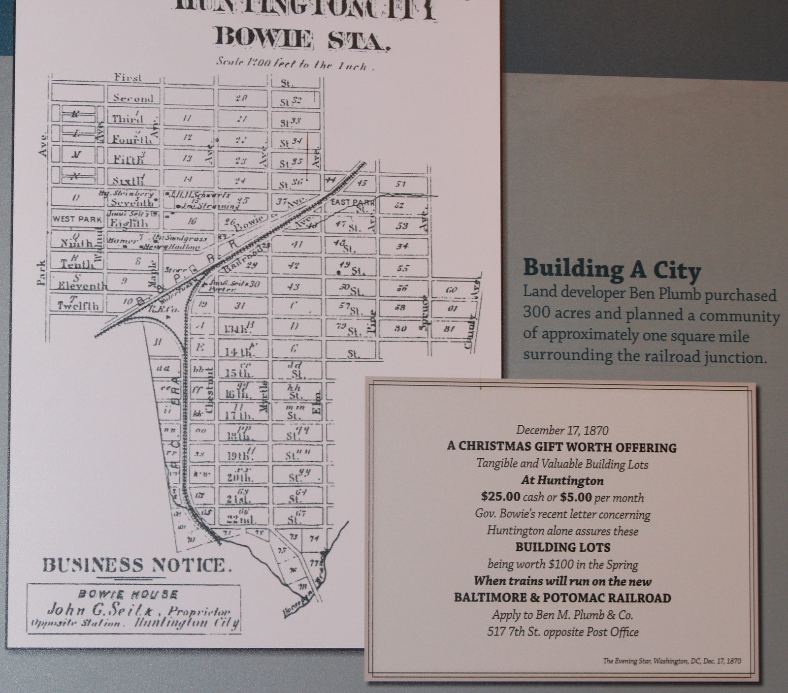
The original Huntington City plat — “Scale 1200 feet to the Inch” — showing Ben Plumb’s street grid surrounding the B&P junction, alongside the December 17, 1870 Evening Star advertisement offering lots at $25 cash or $5 per month. Bowie Railroad Museum display.
Street life and social calendar
Huntington City grew into a bustling village with the railroad station as its heart. Many residents were employed by the railroad or in service occupations, and the social life of the town organized itself around family, church, and the rhythms of the schedule board. Residents attended movies at the Bowie School, dances at the Oddfellows and Knights of St. John halls, and carnivals and medicine shows that passed through regularly. The arrival of the circus train on its way to Washington was always a community event. In 1894, the Methodist Episcopal Church Sunday School offered a “Grand Christmas Entertainment” featuring the county’s largest Christmas tree. St. James Church hosted all-you-can-eat oyster suppers for 25 cents. The Girls Friendly Society put on theatrical events. It was a self-contained world connected, by rail, to everything beyond it.
The town’s commercial streetscape is documented in a series of photographs spanning four decades. The First Methodist Church, built in 1884 on 13th Street near the Pope’s Creek tracks, cost $1,000 to construct. [1884 photograph] The Frank B. Luers House, built on one of Ben Plumb’s original platted lots, faced the railroad directly. [1895 photograph] A 1905 view down Chestnut Avenue from 11th Street shows a livery stable on the left and, on the right, Johnston’s and Nova’s stores side by side with the barber shop between them. [1905 photograph] At the hotel just south of the station, barkeeper Bob Smith stands behind his bar in 1910 amid pressed-tin ceilings and glass shelves stacked with bottles. [1910 photograph] By 1925, the Lancaster children — Calvert, Valerie, and Carlyle (Jiggs) — pose with their dog in front of Hermine Johnston’s store, a building that had been a neighborhood anchor for decades. [1925 photograph]
Mrs. Hermine Erb Johnston
One resident who embodies the character of the town is Mrs. Hermine Erb Johnston, who ran a well-stocked general store on 10th Street for decades. Museum records describe her as a woman of several roles simultaneously: in addition to keeping the store, she was one of the town’s midwives and provided care for the sick and elderly. Described as “a kind, intelligent woman,” she appears to have run the store alone as a widow. She followed current events with genuine interest — museum records single out her fascination with Charles Lindbergh’s transatlantic flight in 1927 as a story that “greatly piqued her curiosity.” Her store interior, photographed from behind the counter, shows the full scope of a late-19th-century general store: produce piled on the counter, shelves packed floor to ceiling with dry goods, baskets hanging from the rafters above. [Photograph of Mrs. Johnston in her store]
What survives and what was lost
Huntington’s decline from a self-contained railroad town to what the Maryland–National Capital Park and Planning Commission’s formal survey describes as a community with significant integrity problems has two main causes: fire, and the eventual shift of development away from the original junction core.
The town burned — more than once. In April 1895, fire broke out around 1 a.m. at the Seitz Hotel, believed to have been caused by an overturned kerosene lamp. A second major fire followed in 1896. The most destructive came in October 1910, when fire swept through the entire business district, destroying eight hotels and stores as well as the railroad signal tower and telegraph wires. All three fires grew quickly out of control for the same reason: Huntington had no local fire department. A town of kerosene lamps and wood-frame buildings, sitting at a railroad junction, burned because there was no organized way to stop it from burning.
The 1910 fire destroyed the Bowie Tower — the interlocking structure that had controlled the junction’s switches since the 1890s — and the Pennsylvania Railroad immediately replaced it. The rebuilt station and tower remained in service until 1989, when MARC opened its new Bowie State University station to the north and the original junction complex fell out of use. The Bowie Railroad Station and Huntington Museum — moved a short distance from the tracks in 1992 and opened to the public in 1994 — preserves the physical memory of the junction district. The full display on Huntington City’s founding is documented at the museum. [Museum display: Huntington City — Where Bowie Began]
Three presidential funeral trains through Bowie
The junction that built the town also kept it on the route of history. For most of the 20th century, nearly everything that moved between New York and Washington passed through Bowie — including three of the most significant funeral trains in American history.
On September 16, 1901, the body of President William McKinley traveled south from Baltimore to Washington on the Pennsylvania Railroad’s main line through the Bowie junction, on its way to lie in state in the East Room of the White House. McKinley had died two days earlier from wounds inflicted by an assassin at the Pan-American Exposition in Buffalo. Aboard the seven-car train, along with McKinley’s widow and the Cabinet, was the new president, Theodore Roosevelt — who had rushed to Buffalo to be sworn in and now accompanied the body back to Washington. The entire PRR main line from Buffalo to Washington that day was a corridor of public mourning: businesses closed, schools let out, and crowds gathered at every station and junction along the route. The train passed through Bowie as evening approached.
On the night of April 14–15, 1945, a second funeral train passed northbound through Bowie: the train carrying the body of President Franklin D. Roosevelt from Washington to Hyde Park, New York, for burial at his family estate on the Hudson River. FDR had died at Warm Springs, Georgia on April 12; his body arrived in Washington on April 14, lay in repose in the East Room, and departed that evening on the final leg north. Hundreds of thousands of people lined the full thousand-mile route. Bowie residents who gathered at the junction that night would have been among the first Marylanders to see the northbound train pass.
The third and most fully documented passage came on June 8, 1968, when a 21-car Penn Central train carried the body of Senator Robert F. Kennedy from New York’s Penn Station to Washington’s Union Station for burial at Arlington National Cemetery. An estimated one to two million people lined the tracks along the full New York–Washington route — the largest public gathering alongside a train in American history. Kennedy had been shot in Los Angeles on June 5 after winning the California presidential primary and died the following day. The train passed through Bowie, and local residents were there. A sixteen-year-old Bowie resident who had volunteered on Kennedy’s presidential campaign waited nearly two hours near the tracks and watched as the flag-draped casket in the last car went by. His account is preserved in TIME magazine’s fiftieth-anniversary coverage of the journey.
The DC spur became the strategic prize
Because the Baltimore and Ohio Railroad opposed a direct Pennsylvania Railroad route into Washington, the B&P charter’s branch-line language became the workaround. By building through Bowie and branching into Washington, the railroad gained the connection that became the dominant north-south passenger approach to the capital — the same line that feeds Amtrak into Union Station today. The Bowie junction was central to that strategy. The spur was arguably the most important twenty miles of track in American railroad history: without it, there is no Pennsylvania Railroad approach to Washington, no electrified Northeast Corridor, no Acela.
Today that corridor carries more than 750,000 people along some portion of its length every single day, aboard 2,200 trains. In 2024, nearly 14 million passengers traveled on Amtrak alone between Washington and Boston; between New York and Washington, Amtrak carries roughly five times as many passengers as the airlines. Seventy freight trains use the corridor daily, moving more than 350,000 carloads of goods a year. The junction that Oden Bowie lobbied the Maryland legislature to authorize in 1853 now sits at the center of the most intensively used rail corridor in the Western Hemisphere.
None of those trains stop at Bowie — MARC commuter service does reach the Bowie State University station on the same corridor, but the original station at the historic junction closed in 1989 when the new stop opened, and its buildings now house a museum. The junction that built the town no longer stops for anyone.
The junction itself still functions — CSX freight trains branch off the Northeast Corridor at Bowie onto the Pope’s Creek subdivision, the same line that carried tobacco south and race-day crowds north a century ago. But for passengers, Bowie is a blur outside the window. The Acela passes through at 125 miles per hour. The commuter reading on the Northeast Regional between Washington and Philadelphia, the freight engineer threading a coal train south toward the power plants — they all pass through the junction without knowing what it is or was.
The Washington terminus of the line that created Bowie’s junction is also where President Garfield was shot
The Baltimore & Potomac Railroad that created Bowie’s junction had its Washington terminus at the B&P Railroad Station at Sixth Street and Constitution Avenue NW — on the site now occupied by the National Gallery of Art’s West Building. On the morning of July 2, 1881, President James A. Garfield entered the station to board a train for his summer vacation, passing through the Bowie junction en route. Charles Guiteau, a delusional office-seeker who believed Garfield owed him a diplomatic post, shot the president twice from behind in the waiting room. Garfield survived the shooting but died 79 days later of the sepsis caused by doctors probing the wound with unsterilized instruments.
The connection to Bowie is direct: every passenger who rode the B&P through Bowie’s junction passed through that same station. The Woodwards used it to visit Belair from New York. Race fans used it on the way to Prince George’s Park. Garfield was shot at the gateway to the railroad that built the town. The assassination led directly to the Pendleton Civil Service Reform Act of 1883 — the law that professionalized the federal civil service that Bowie-area residents have worked in ever since.
The WB&A — Bowie’s second railroad
While the B&P anchored the junction town, a second and very different railroad ran through what is now the WB&A Trail corridor — and left behind one of the more colorful footnotes in local history.
A state-of-the-art interurban
The Washington, Baltimore and Annapolis Electric Railway began operating in February 1908. Where the B&P ran steam locomotives on a conventional railroad, the WB&A was an interurban — an electric railway using self-propelled cars on their own dedicated right-of-way, a technology that flourished in the early twentieth century and has almost entirely vanished. At its best the WB&A ran at speeds of up to 70 miles per hour, with departures every half hour between destinations. Despite the fact that the railroad was rarely profitable, service was fast and on time.
At its peak during World War I the WB&A ran 33 scheduled trips a day between Washington and Baltimore, carrying 5.9 million riders a year. A round-trip fare between the two cities cost $1.25 in 1909, with the journey taking only 65 minutes each way. Stops along the route near Bowie included Bowie, Lloyd, Highbridge, Hillmeade, Bell, Randle (serving Glenn Dale Hospital), Lincoln, Buena Vista, and Cherry Grove. Several of those station names are still readable on the local landscape — Hillmeade Station Road near Bowie is one legacy; the Marley Station Mall on Route 2 in Anne Arundel County is another, sitting along the segment of the WB&A corridor that later became the Baltimore & Annapolis Trail. The Bowie Race Track owed its location in part to the WB&A: the track’s founders chose the site specifically because the railroad could add a spur directly from its main line.
The Bootlegger Specials
The WB&A’s most colorful footnote dates to the fall of 1918. Congress, exercising its direct authority over the District of Columbia, had outlawed the sale of alcohol in the District — while Maryland had not. National Prohibition via the 18th Amendment was still more than a year away; for a brief window, a WB&A ticket northbound was the most practical route around a dry law. The railroad obliged the demand: six additional daily trains were added to the schedule to accommodate Washingtonians riding to Baltimore to buy alcohol. These trains were informally known as the “Bootlegger Specials.”
Maryland’s resistance to Prohibition was genuine and well-documented. The state declined to pass legislation enforcing the federal ban, and Governor Albert Ritchie opposed the 18th Amendment throughout his four terms in office. Baltimore was a willing and convenient destination. The Bootlegger Specials operated in the narrow window between the DC-specific ban and the start of national Prohibition in January 1920.
Closure and legacy
The Great Depression took its toll on the WB&A. The railroad ceased operations in August 1935 after Maryland withdrew its tax exemption; the tracks were removed shortly thereafter. The right-of-way through Prince George’s and Anne Arundel County survived, however, and eventually became the WB&A Trail. The Prince George’s County segment — 7.4 miles running from a trailhead at MD 450 (Annapolis Road) in Glenn Dale through a wooded corridor past the tunnel under Route 193 and north through Bowie to the Patuxent River — opened in stages beginning in 2000. The Anne Arundel County segment adds another 5.7 miles from the river south to Odenton. For decades the two segments were separated by the unbridged Patuxent; the old WB&A railroad bridge had been scrapped in the 1930s and its concrete abutments were all that remained. A new 530-foot pedestrian and bicycle bridge — nearly 30 years in the making and costing $6.5 million — opened to the public in May 2025, with an official ribbon-cutting ceremony on September 16, 2025. The completed trail now runs nearly 13 continuous miles from Odenton to Glenn Dale and forms part of three national trail networks: the East Coast Greenway, the American Discovery Trail, and the 9/11 National Memorial Trail. The Bootlegger Specials story and the WB&A’s operational history are documented on interpretive signs along the trail.
The WB&A’s right-of-way did not all become a single trail: the Baltimore-to-Annapolis portion of the corridor became the Baltimore & Annapolis Trail, which connects at its northern end via the John Overstreet Connector to the BWI Airport Trail — together forming one of the most-used trail corridors in the region. A planned extension of the WB&A Trail northward from Odenton along the original right-of-way to meet the BWI Trail has been in feasibility studies since 2019, with county officials on record that the WB&A Trail will eventually connect with the B&A and BWI trails. If that extension is ever built, a rider could travel the full geographic reach of the old WB&A railroad — from Glenn Dale to the doorstep of Baltimore — without leaving a trail.
A personal note — two trails and a recumbent. The author came to cycling in earnest around 1998, first exploring the network of paved paths that wind through Bowie’s Levitt-era neighborhoods from north to south — paths built into the community from the beginning, long before “trail” became a planning category — then upgrading from a generic steel-frame 10-speed to an aluminum Raleigh hybrid. The real conversion came around 2000 with the purchase of a BikeE recumbent — then the world’s best-selling recumbent. Where a conventional bike puts your weight on your hands, your seat bones, and your wrists, the BikeE distributed it across a full seat and backrest, and its full suspension — front and rear — soaked up everything the road threw at it; you could drop off a curb without a second thought. That same suspension contributed to a slight loss of pedaling efficiency, the inevitable tradeoff between comfort and performance. The view of the road ahead — rather than the road beneath your wheels — made long distances feel entirely different. The BikeE went out of business in 2002; by then, the author had upgraded to a Burley Django, a short-wheelbase recumbent that was a speedster by comparison. At peak fitness, riding the WB&A and B&A/BWI Airport Trails hundreds of times and logging close to a hundred miles some weeks, the author occasionally heard from road cyclists that he was the fastest recumbent rider they’d seen on the trail — which is the kind of compliment you remember. In those years, the two trail segments were still separated by the unbridged Patuxent, and the B&A connection was even further out of reach. Getting to either trail meant loading the bike onto a car. The new Patuxent bridge and the planned Odenton extension finally make the connection the author wished for twenty years ago at least imaginable.
The physical memory of the railroad era
Two surviving buildings from the railroad and early-20th-century landscape of Old Bowie — documented in the Illustrated Inventory of Historic Sites and Districts.
Bowie Railroad Buildings / Huntington Museum — Chestnut Avenue
This complex of a two-story signal tower, freight/ticket office, and passenger shelter once managed freight, ticket sales, and train movements at the Bowie junction. Moved a short distance from the tracks in 1992, it now operates as the Bowie Railroad Station and Huntington Museum — the last substantial physical reminder of the original rail town core. The City of Bowie purchased the structures in 1991 and the museum opened in 1994, joined in 2006 by the restored 1926 Bowie Building Association structure next door as the Old Town Bowie Welcome Center and Children’s Museum.
Edlavitch-Harmel House / Mitchellville Storekeeper’s House · Mitchellville Road
The building now known as the Edlavitch-Harmel House stands near the corner of Mitchellville and Mount Oak Roads — the heart of what was once the Mitchellville/Mullikin stop on the Pope’s Creek line. A general store operated by Samuel Domer was here by the 1870s, around which developed a small community with a stable, garage and gas pump, bar, poolroom, barber shop, feed mill, post office, blacksmith, school, and hotel. The Edlavitch family — Russian Jews who immigrated to the area in 1888 — purchased the store in 1895 and built this two-story frame house with its unusual two-level porch in 1906. Joseph F. Montgomery, who ran the store from 1925 to 1943, was one of the first African American businessmen in the area. The last owners were the Harmel family. The store burned in 1985.
The gas pump from the Mitchellville store — a Wayne Pump Company Amoco pump dating to around 1935, restored to its original red and black livery — was preserved when the City of Bowie acquired the property in 1992 and is now on display at the Belair Stable Museum, where it serves as a reminder of the quiet farming communities that once dotted the local landscape.
The building stands near the corner of Mitchellville and Mount Oak Roads. Historical records document the two names as a single railroad hamlet: an 1878 atlas shows “Mitchellville P.O.” at this corner, while the USGS formally catalogued the stop as “Mitchellville (Mulliki’n)” in its railroad guide notation. The storekeeper’s house is the only structure from that hamlet that survives. Since 1999 it has housed the Radio and Television Museum — a small but dense collection that traces broadcast history in the same county where early radio and television became everyday fixtures. The Mullikin family and this crossroads hamlet are discussed further in Chapter 1.
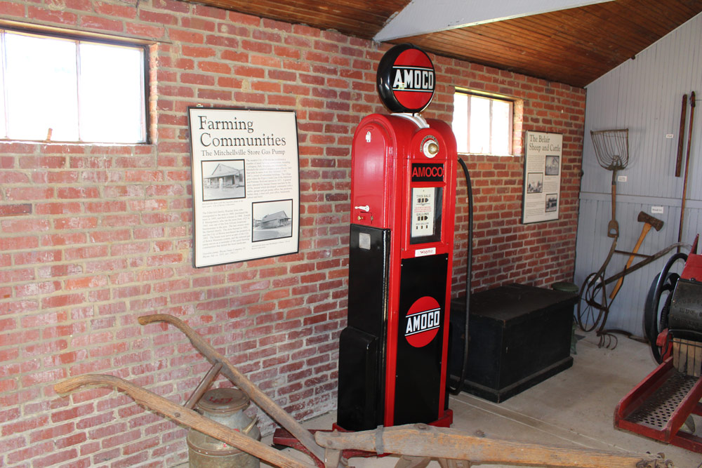
The Mitchellville Store’s Amoco gasoline pump — a Wayne Pump Company model dating to around 1935, restored to its original red and black livery — on display at the Belair Stable Museum alongside the Farming Communities interpretive panel. Photo by the author, 2016.
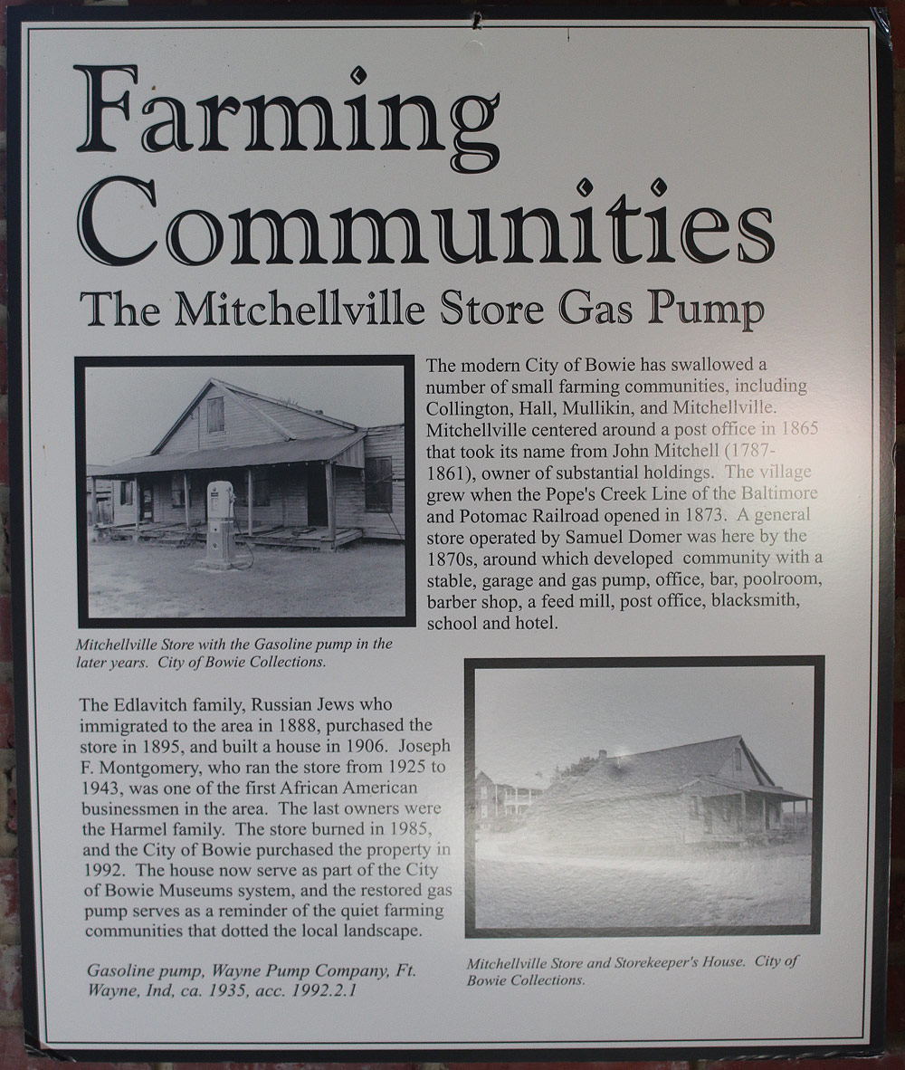
Farming Communities: The Mitchellville Store Gas Pump — interpretive sign at the Belair Stable Museum. The upper photograph shows the store with the gasoline pump visible on the porch in its later years; the lower photograph shows the store and storekeeper’s house. Both images from City of Bowie Collections. Photo by the author, 2016.